The South China Sea
The South China Sea has long been sailed by ships carrying spices and luxuries between China and countries far away. Since 1949 the ‘ownership’ of the area has been disputed by all the neighboring states including China.
The sea occupies a vast area south of Hainan Island and Guangdong of about 772,204 sq miles [2,000,000 sq kms]. It would extend Chinese control nearly to the Equator, nearly to the coast of Borneo. There are two regions of very small islands barely above sea level: the Spratly Islands and the Paracels. They are both made up of coral atolls - areas of former coral reef that cap submerged volcanic islands. The shallow waters have been a hazard for boats for centuries and they were only inhabited for brief periods by pirates and fishermen as there are no reliable sources of fresh water. It was an area to be avoided at all costs and maps were of great value to ensure safe navigation around them.
Paracel Islands 西沙群岛 Xī shā qún dǎo and (Hoàng Sa in Vietnamese)
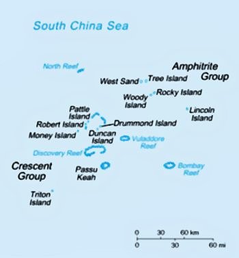
These are far to the north of the Spratlys and comprise 130 largely barren islands. The Paracels lie on a busy shipping lane and many merchant ships pass close to the islands. They are divided into the eastern Amphitrite group and the western Crescent group. It is home to many sea turtles which are now over-collected for food and tortoiseshell. There was early visits by both Chinese and Vietnamese fishermen.
The Paracles are claimed by Vietnam, Taiwan and China although China believes that the North Vietnamese at one time waived their claim. Woody Island is the largest island of the Amphitrite group and has an airstrip with various military facilities. The name ‘Paracel’ comes from the Spanish ‘pracel’ or ‘parcel’ which refers to a shallow, sandy stretch of sea water and this name was used by the Portuguese sailors of the 16th century. The larger islands ‘Duncan’, ‘Drummond’, ‘Money’, ‘Pattle’ and ‘Roberts’ are named after senior executives of the British East India Company. ‘Woody’ island is named because of the many palm trees that grow on it (most of the other islands do not support any vegetation).
In the 16th and 17th century the sea routes through the South China Sea were of great importance. The Spanish and Portuguese were followed by the Dutch and English, all keen to develop trade links with China and Japan. The Selden map of 1608 was one of the most accurate and it was highly prized at the time as it permitted sea captains to plot courses avoiding the perilous shoals.
Spratly Islands南沙群岛 Nán shā qún dǎo
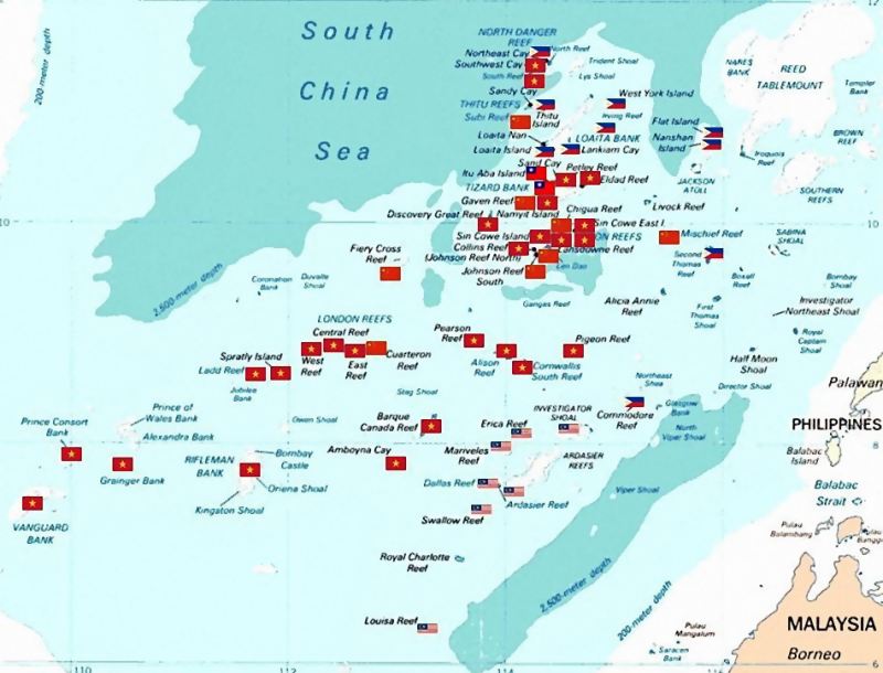

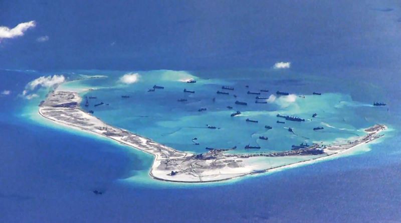
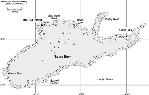
The Spratlys are about 600 miles [966 kms] further south and has about 400 islets and reef atolls - none more than a mile long; about 150 of them are named. The total land area is only 1 sqmile [2 sq kms] land spread over 164,093 sq miles [425,000 sq kms] of ocean. It is a collection of rocks and deeps which are very dangerous to shipping. They are named after Richard Spratly ➚ (1802-1870) a British whaling captain who sighted and mapped them on 29 March 1843. He was pleased to discover deposits of guano (bird poo) as that was a high value commodity at the time as a rich crop fertilizer. The islands include ‘Ladd Reef’ that was named after Captain Ladd at about the same time. They were previously known as ‘Horsburgh’s Storm Island’ because they were first noted on the map of James Horsburgh ➚, a hydrographer of the British East India Company in 1821. Taiwan, Malaysia, Philippines and China all have some sort of permanent presence on one or two Spratly islands. Malaysia has developed the Layang Layang ➚ island as a tourist resort.
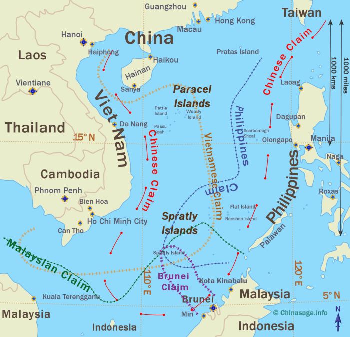
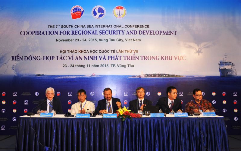
Sovereignty claims to the South China Sea
The map indicates the rough claims on the territory from the neighboring states: China, Vietnam, Malaysia, Brunei, Taiwan and the Philippines. The rush to make claims seems to have begun in 1945 after the US started treating territorial waters as sovereign territory. The UN Law of the Sea ➚ states that if an island has been put to economic use then a nation can claim a special zone around them so there has been a rush to occupy and develop the islands. There are large oil and gas reserves near the Spratlys, as well as abundant fish. Important shipping lanes pass through them to China, Taiwan and Japan so they also have strategic importance. China’s claim was made just before the foundation of the People’s Republic in 1947, it is the largest claim - taking the country close to the 5° north latitude. It would make Hainan the largest Chinese province by area. The line of the claim on the map is usually drawn in nine sections and so is called the ‘Nine dash line ➚’. The South China Sea is not the only area of disputed sovereignty with China, Japan and China continue to posture over the Diaoyu (钓鱼岛)/Senkaku islands ➚ that lie between Taiwan and Japan.
China's claim
To the Chinese it is the ‘south sea’ (南海 Nán hǎi) and to Vietnam the ‘east sea’ Biền Đông 匾東. The Chinese claim is on the supposition of ‘historic claims’ under International law. Old Chinese maps of the area show the islands and that Chinese artifacts have been found on the islands dating back to the Tang and Song dynasties. In the Ming dynasty Admiral Zhōu Mǎn 周滿 (b.1378) took part in Zheng He's famous voyages of exploration (1405-1433). Zhou Man reached the Philippines and Australia. Admiral Hóng Bǎo 洪保 separated from Zheng He's main fleet at Sumatra and explored the Spice Islands over to Arabia. Zhou Man's map of the South China Sea indicates that the islands were known to the explorers at this time.
In written Chinese documents there is a possible description as ‘1,000 stretches of sand’ 千里长沙 Qiān lǐ cháng shā in the Song dynasty book ‘A Description of Foreign Nations’ 诸蕃志 Zhū fān zhì (c.1225). A Ming dynasty map also shows the islands as 石星石塘 shí xīng shí táng ‘Stone fragments and stone pools’.
In the following period from 1433 to about 1960 the Chinese government had no effective navy and showed little interest in controlling the sea. The South China Sea became the dominion of pirates and merchant traders. In the early 19th century there was about 70,000 pirates on 800 vessels marauding the South China Sea. It was the British occupation of Hong Kong from 1842 onwards that eventually cleared the sea of pirates. In 1849 a generous reward for pirates stimulated many to hunt them down - at £20 for each dead or captured pirate - to make it a tempting prospect.
An 1867 British survey found Chinese people in the Spratlys living on turtle shells and eggs but only made viable by regular re-provisioned by boats from Hainan. Official Chinese interest in this area was stimulated in 1900 when German surveyors studied the islands. This led to protests in China and to the emplacement of Chinese flags on some of islands in 1902. Of the two island groups the Paracels are much closer to China and they are strategically more important. In the Second World War (1937-45) Japan used the Spratlys as a base to attack the Philippines and then on their defeat the effective control of the islands was taken up by the Republican government in Taiwan.
In 1956, a Filipino adventurer Tomás Cloma, claimed part of the islands as his own new country, and called it the ‘Free Territory of Freedomland ➚’. In 1974 Cloma was arrested and his rights to the islands taken over by the government of the Philippines.
Conflicts and skirmishes
China in the same year (1974) took six Spratly islands from Vietnam by armed force and there was further conflict when Vietnamese were driven off the western Paracel islands. In 1984 Deng Xiaoping suggested the idea of ‘joint development’ of South China Sea as the way forward but as this had China as the dominant partner the offer was not taken up. It has also been proposed that a ‘One country two systems’ model similar to Hong Kong and Macau could be applied. In 1988 China built on Fiery Cross Reef (永暑礁 Yǒng shǔ jiāo) in the Spratlys. [It is named after ‘Fiery Cross’ a British Tea Clipper that sank there on 4th March 1860]. It was then attacked by Viet Nam but repulsed with 72 Vietnamese troops killed and three Vietnamese boats sunk - this can be seen as a continuation of Vietnam-China war of 1979.
The situation escalated in 1992 when China made a declaration about its territorial seas - covering the whole area of the South China Sea or 12 mile radius from all the atolls. The declaration forbade the surfacing of submarines and the passage of surface vessels. As somewhat of a counteraction in 1992 Chevron, an American company was given a contract to look for oil in the South China Sea with potential US military support and also tacit Taiwanese support. In recent years Taiwan and the PRC have unofficially worked jointly for Chinese development of the area. By 1994 no oil had been found, however continued exploration led to a Chinese oil rig being installed in the Paracels in 2014. Oil reserves may be as high as 7.7 billion barrels in a very sensitive ecological area.
An ASEAN ➚ meeting in 1992 produced a declaration that called for the peaceful resolution of the claims. In 1994/95 China took control of ‘Mischief Reef’ in the Spratlys west of Palawan Island and erected shelters. The Philippines naturally objected and threatened military action. The move in 1997 by China at another ASEAN meeting to renounce the use of force has done little to reduce tensions, for very soon, in 1999 the Philippines agreed for the US to increase their naval presence. This came after the US had detected (29/1/1999) the building of a Chinese base on Woody Island (Yongxing) (260 miles east of Da Nang) as a refueling depot for air control of the whole area (including AWACS - Airborne Warning and Control System) . China claimed that this was part of a plan to develop the area for tourism.
Administration
China's claim is administered from Hainan Island. In 2007 China set up the Sān shā 三沙 municipality over three Spratly Islands which caused more upset in Vietnam. The Paracels are administered from Woody Island 永兴岛 Yǒng xīng dǎo.
In 2016 an International panel rejected China’s claim to ‘Mischief Reef’ in the Spratlys on the basis it was submerged at high tide and ceded it to the Philippines. Chinese President Xi Jinping rejected the decision by the Permanent Court of International Arbitration that ruled the 'nine dash line' was not lawful. On Jan 6th 2016 China successfully carried out test fights of two civilian aircraft from a new airfield on Fiery Cross Reef. In October 2019 Vietnam banned the Dreamworks film ➚ 'Abominable' because it has a brief scene showing a map with the 'nine dash line'.
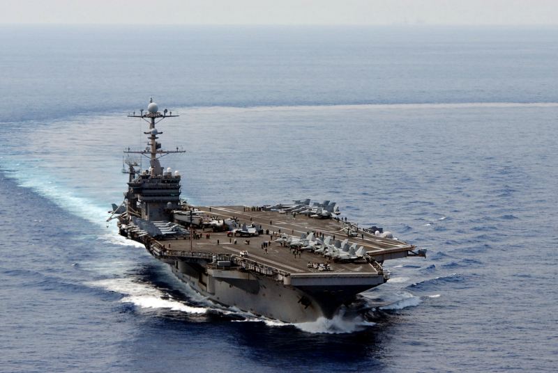
More recently on 28 May 2018 two US warships passed close by the Paracel Islands much to the annoyance of the Chinese. The Chinese claimed they did not have permission, while the US disputes the need to have it. Both Chinese and America continue to carry out naval exercises in the area. The US is still heavily involved in the defense of both Taiwan and the Philippines (see our One China Policy page). Britain sailed its new aircraft carrier HMS Queen Elizabeth through the area in July 2021.
Only time will tell if some sort of amicable agreement can be reached over the control and development over the this huge area of ocean and its many islands.
Bing map of South China Sea ➚