The Climate of China
China Climate
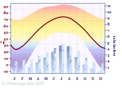
This chart shows the huge temperature range of the climate of China. For climate profiles of individual provinces please see the individual province descriptions. The average temperature and rainfall is weighted according to each province's area and because of the vast area of Tibet and Xinjiang provinces it is generally lower than would be expected. In winter and spring an anti-cyclone often sits over Mongolia bringing east and south-easterly winds. In winter extremely cold Siberian air is drawn into north-east China. In summer and autumn the prevailing wind is reversed except for the dry north-west; allowing moist, warm air from the South China Sea to move north. Depressions generally track westward, bringing welcome rain to inland provinces. Rainfall varies considerably from year to year in inland areas leading to risk of drought or flood, particularly during the summer. Typhoons from the South China Sea are a frequent hazard in late summer and autumn, affecting mostly Fujian Guangdong and Zhejiang.
Visitors generally find spring and autumn the best times to come to China in order to avoid the extremes of hot, wet and cold. For all about visiting China see our visitors guide.
Temperature in China
Winter
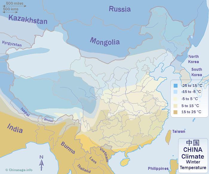
The average temperature over China in winter (January) demonstrates the extent of cold conditions over much of China. Cold north-easterly winds result in very low temperatures as far south as Beijing. The high Tibetan plateau is very cold. Only the southernmost coastal fringe retains temperatures over 59 ° F [15 ° C]. The extreme northeast is coldest with temperatures as low as -22 ° F [-30 ° C] at times.
Summer
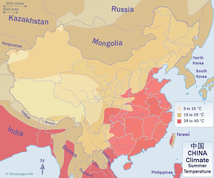
This map shows the average temperature over China in summer (July). Southerly winds bring frequent rain and high temperatures to most of southern China; the Yangzi basin and as far north as Beijing. Several large cities exceed 104 ° F [40 ° C] on hot days. Chongqing; Wuhan andNanjing are known as the 'three furnaces' of China 三大火炉; only the high Tibetan plateau remains cool. The long warm period in the south allows the growing of two or three crops of rice.
Rainfall in China
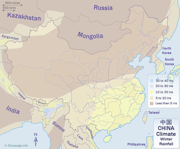
Winter
China in winter (November to April) is generally dry. The bulk of China is under the influence of cold dry air from the north east and there is little rain or snow. Far eastern Xinjiang receives some rain, south of the Yangzi moderate rainfall continues all year round.
Summer
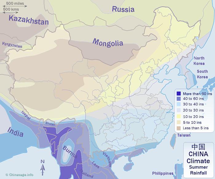
In summer (May to October) China receives most of its rain. Monsoon rain affects southernmost Tibet and Yunnan. Frequent rain bearing depressions moving in from the South China Sea bring heavy rain along the southern coast. The rain reaches as far north as the Yangzi, although the amount of rainfall drops off gradually towards Xinjiang in the north-west.

Record breaking conditions
These are the provinces with the coldest/hottest and driest/wettest statistics in China.
Wettest province
The wettest provinces (as measured at the provincial capital) for each month of the year. In spring it is Jiangxi while in autumn/fall it is southernmost Hainan Island.
MonthProvinceExtremeinchcmsJanHunan 24.061.0
FebJiangxi 40.2102.0
MarJiangxi 59.4151.0
AprJiangxi 88.2224.0
MayGuangdong 111.8284.0
JuneJiangxi 111.0282.0
JulySichuan 90.9231.0
AugHainan 88.6225.0
SeptHainan 98.8251.0
OctHainan 79.1201.0
NovHainan 38.297.0
DecZhejiang 18.948.0
Driest province
The provinces (at the provincial capital) with the least rainfall for each month of the year. They are all in the west or north-west of China.
MonthProvinceExtremeinchcmsJanTibet 0.20.5
FebTibet 0.30.7
MarTibet 0.82.0
AprTibet 2.05.2
MayNingxia 6.717.0
JuneNingxia 7.519.0
JulyXinjiang 7.920.0
AugXinjiang 6.316.0
SeptNingxia 9.123.0
OctTibet 4.010.2
NovTibet 0.71.7
DecGansu 0.41.0
Hottest province
Provinces with the highest maximum temperature for each month of the year. Southernmost tropical province of Hainan features heavily, but in summer/autumn provinces further east are even hotter.
MonthProvinceExtreme° F° CJanHainan 69.420.8
FebHainan 71.622.0
MarHainan 78.325.7
AprHainan 85.129.5
MayHainan 89.632.0
JuneHainan 90.732.6
JulyFujian 93.234.0
AugHunan 92.533.6
SeptGuangxi 89.131.7
OctGuangdong 83.528.6
NovHainan 77.225.1
DecHainan 71.822.1
Coldest province
These are the provinces with the lowest temperature for each month of the year. The northernmost province Heilongjiang is coldest in winter, but in summer it is Tibet in the west.
MonthProvinceExtreme° F° CJanHeilongjiang -12.3-24.6
FebHeilongjiang -6.3-21.3
MarHeilongjiang 13.6-10.2
AprHeilongjiang 32.00.0
MayTibet 41.05.0
JuneQinghai 48.69.2
JulyTibet 50.210.1
AugTibet 48.99.4
SeptQinghai 45.57.5
OctHeilongjiang 31.8-0.1
NovHeilongjiang 13.1-10.5
DecHeilongjiang -4.5-20.3